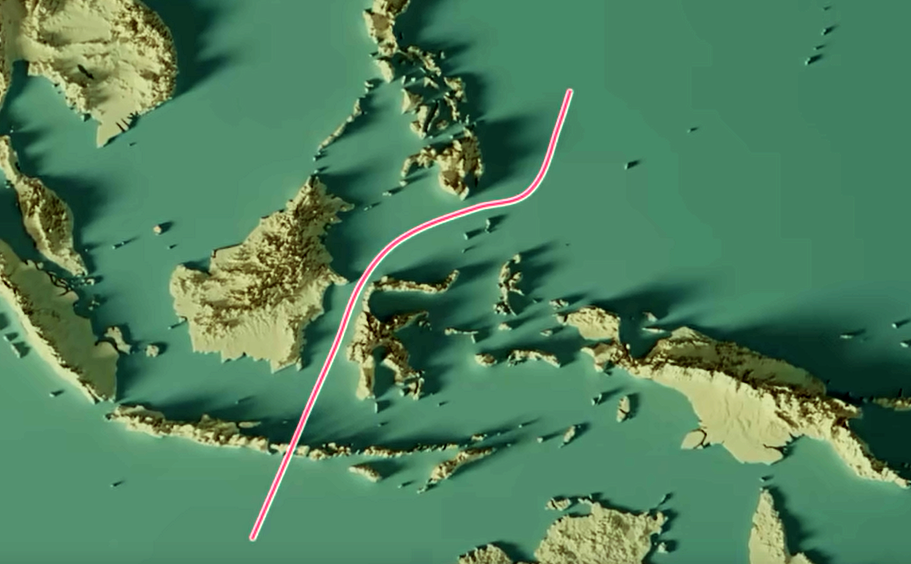
These lines are imaginary lines that delineate distinct biogeographic regions based on the distribution of flora and fauna. They were proposed by renowned naturalists to explain the unique biodiversity patterns observed in various parts of the world.
Wallace Line
- Proposed by: Alfred Russel Wallace
- Location: Runs between the islands of Bali and Lombok in Indonesia.
- Significance: Separates the Oriental realm (Asian fauna) from the Australasian realm (Australian fauna).
- Reason: Deep ocean trenches between the islands have acted as a barrier to migration, leading to distinct faunal assemblages on either side.
Weber Line
- Proposed by: Max Carl Wilhelm Weber
- Location: Lies to the west of the Wallace Line.
- Significance: Separates the Sunda Shelf (continental shelf connecting Southeast Asia and Borneo, Sumatra, and Java) from the Sahul Shelf (continental shelf connecting Australia and New Guinea).
- Reason: A deeper oceanic trench between the two shelves has limited faunal exchange, leading to distinct biogeographic provinces.
Lydekker Line
- Proposed by: Richard Lydekker
- Location: Lies to the east of the Weber Line.
- Significance: Separates the Sahul Shelf from the Wallacea region (a transitional zone between the Oriental and Australasian realms).
- Reason: A deep ocean trench between the two regions has limited faunal exchange, leading to distinct biogeographic provinces.
Visual representation:
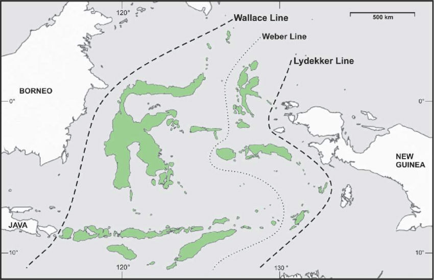
These lines are important tools for understanding the historical and ecological processes that have shaped the distribution of species on Earth. They highlight the impact of geographic barriers, such as deep ocean trenches, on the evolution and dispersal of organisms.
Author: Arjun Kr. Paul, Faculty, ACS
Comments (0)
Categories
Recent posts
Q5/ Section B, APSC Mains 2024 Essay - ...
29 Jul 2024
Satellite Town
21 Jul 2024
Q 1/Section A, APSC Mains 2024 Essay - ...
29 Jul 2024